| Height: | 336.29+ ft | (102.50+ m) | Elevation: | 195 ft (59 m) | GPS Latitude: | 40.34644 |
| Volume: | 31,146 ft3 | (882 m3) | Creek: | Bull Creek | GPS Longitude: | -123.96236 |
| Width: | 21.33 ft | (6.50 m) | Grove: | Middle Bull Creek Flat | Discovery Date: | 1992 |
| Age: | 1,766 y | Park: | Humboldt Redwoods SP | Discovered By: | Michael W. Taylor |
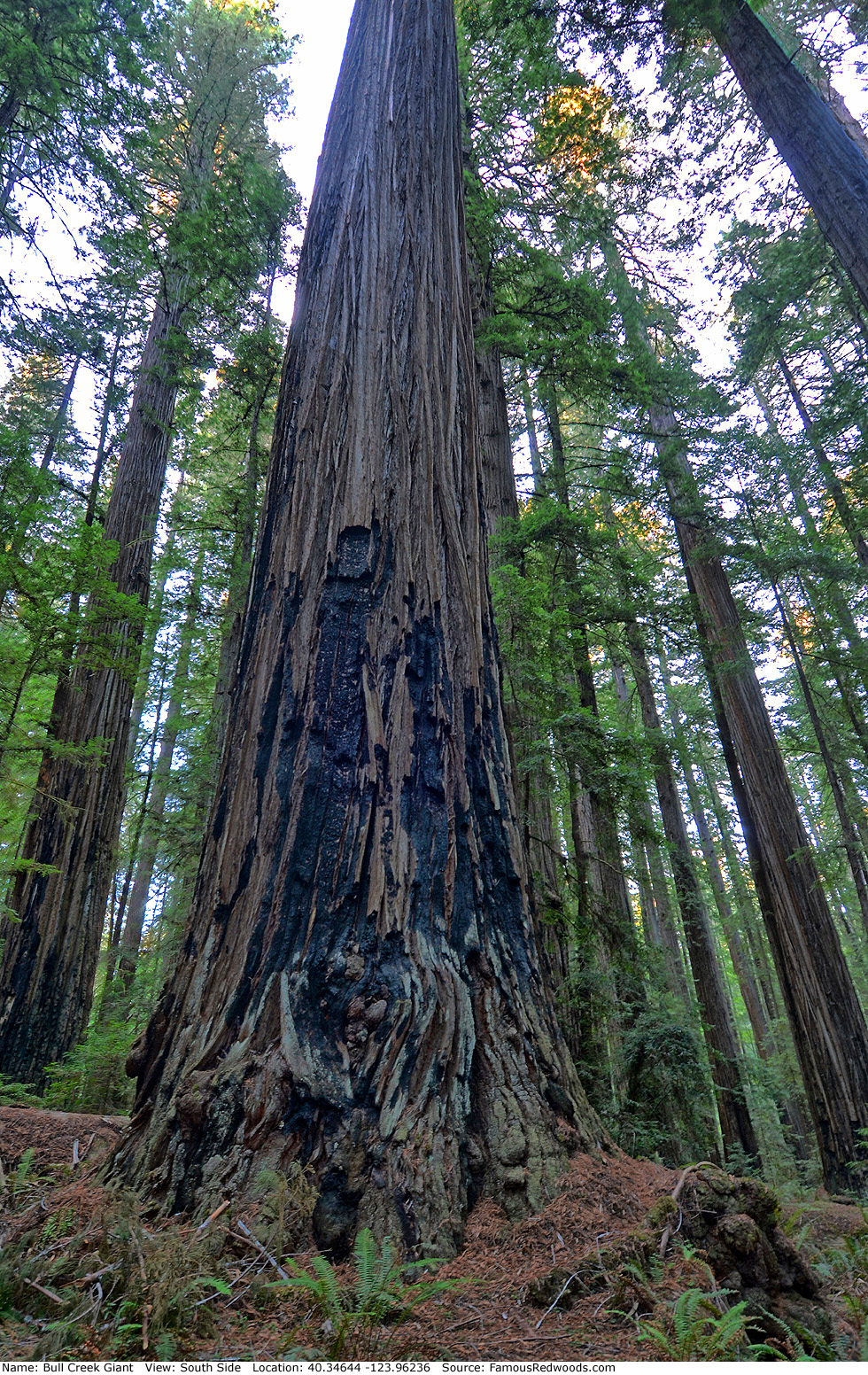
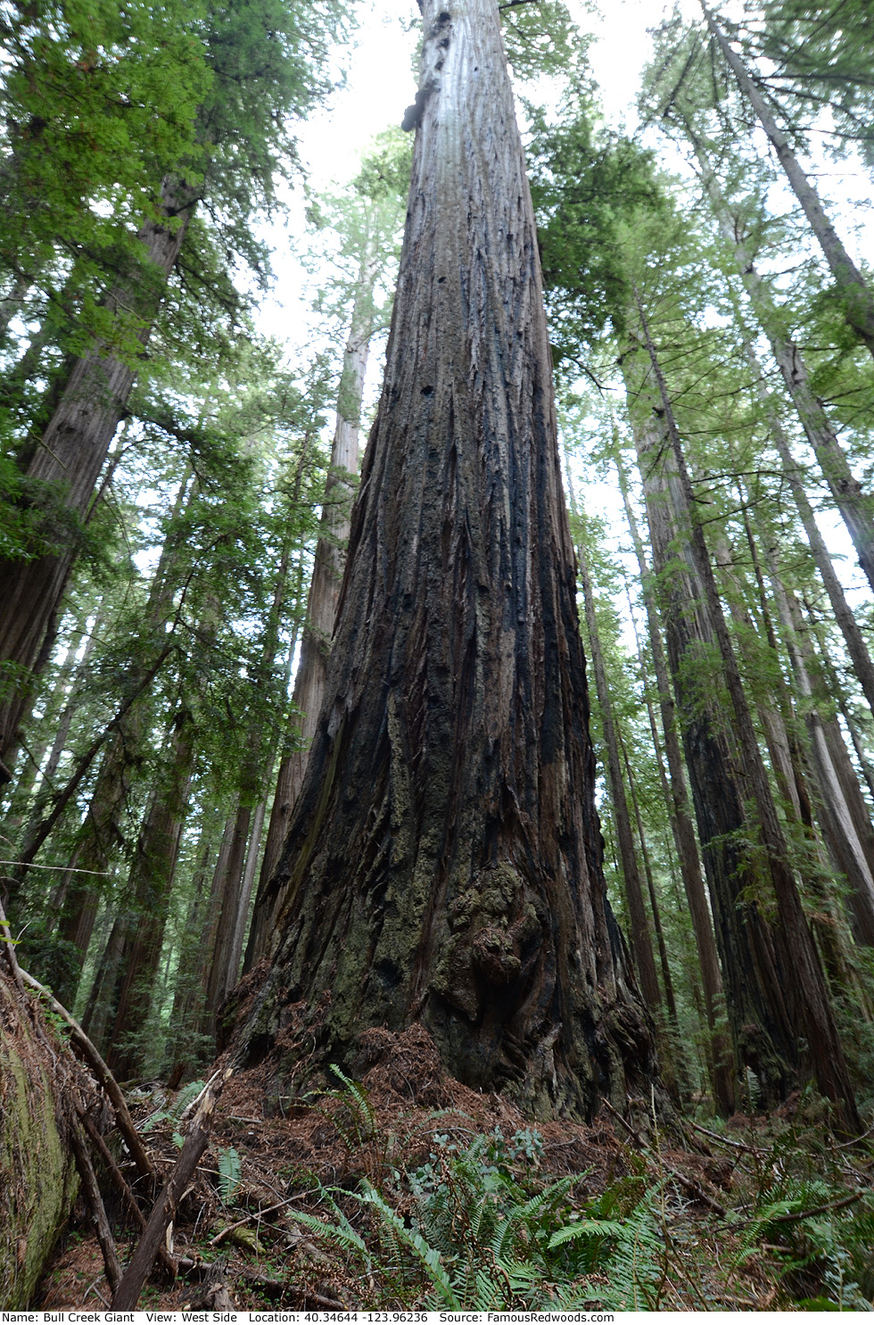
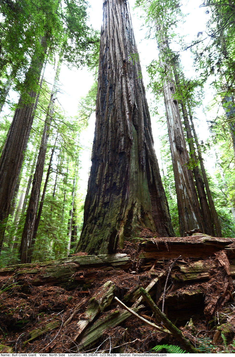
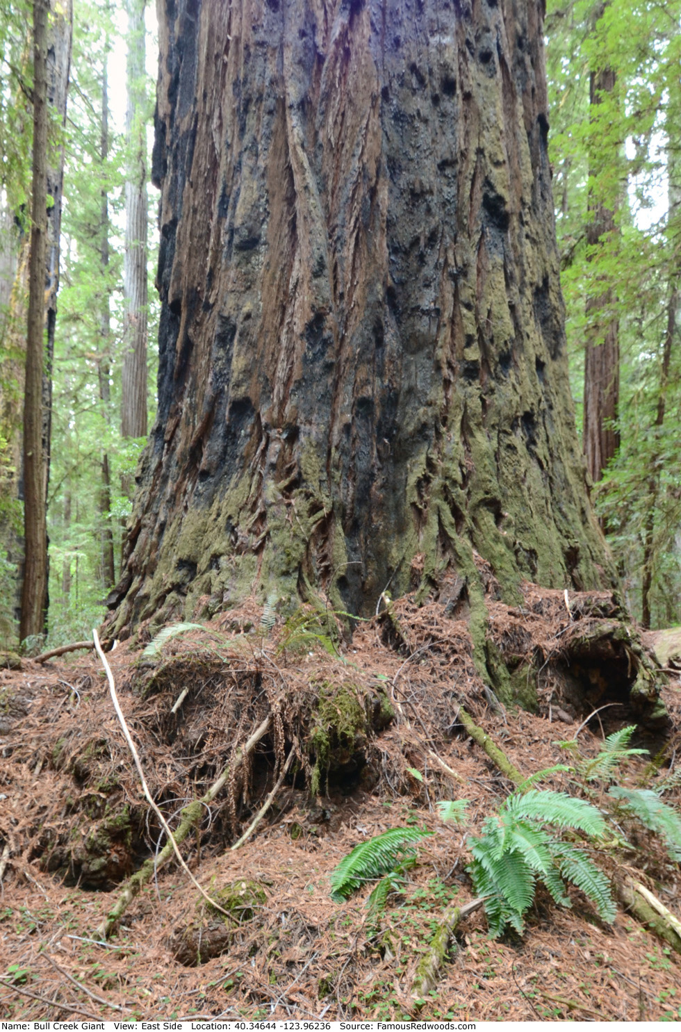
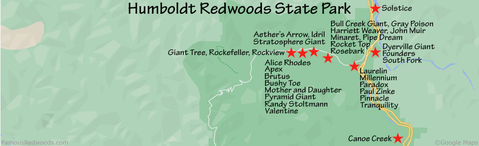
Notes: Bull Creek Giant, also known as Gaia, is the 9th largest coast redwood and the largest tree in Humboldt Redwoods State Park.
Bull Creek Giant appears on the cover of Robert Van Pelt's book Forest Giants of the Pacific Coast. National Geographic photographer Michael K. Nichols photographed the trunk of Bull Creek Giant from a nearby tree. Forest ecologist Christopher J. Earle photographed author Richard M. Preston and his daughter Laura H. Preston climbing Bull Creek Giant and the view from the treetop. Preston photographed the view looking down the south side of the trunk. Cal Poly Humboldt forestry professor Stephen C. Sillett published a 360-degree panorama of Bull Creek Flat taken from the top of Bull Creek Giant and photographed Bull Creek Giant's flat-topped crown from the crown of John Muir. University of Washington forestry affiliate assistant professor Robert Van Pelt published an orthographic illustration of Bull Creek Giant (shown 2nd from right).
The area surrounding Bull Creek Giant is also known as Patriarch Forest and Patriarch Grove.
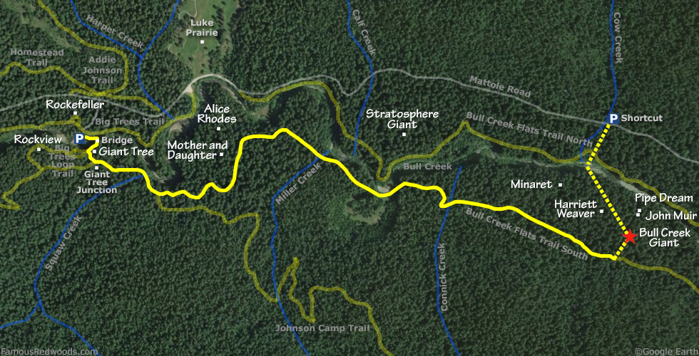
Drive: Bull Creek Giant is 196 mi (315 km) north of San Francisco near the community of Weott.
Northbound: From U.S. Highway 101 just north of Weott, take exit 663 South Fork Honeydew and turn left onto California State Route 254 (Avenue of the Giants). Drive north 0.2 mi (0.3 km) on California State Route 254 (Avenue of the Giants) and turn left, under the bridge, onto Mattole Road.
Southbound: From U.S. Highway 101 just north of Weott, take exit 663 South Fork Honeydew and turn right onto Mattole Road.
Drive west 4.4 mi (7.1 km) on Mattole Road to the entrance for the Big Trees Day Use Area. Turn left here and continue to the Big Trees Day Use Area parking lot.
Shortcut: Take this shortcut, which reduces hiking time by 40 minutes each way, to visit Bull Creek Giant when Bull Creek is low enough to wade across. Park at a turnout on the right/north side of Mattole Road near Cow Creek.
Hike: GPS-assisted navigation is recommended for this hike. From the parking lot, hike toward Bull Creek and cross the seasonal footbridge, if available. The trail veers left/east just after you cross the footbridge. In 400 ft (122 m), turn right/south toward Giant Tree. Pass to the right of Giant Tree and, when you reach the first Bull Creek Flats trail marker, turn left. When you reach the Johnson Camp Trail sign, turn left again toward the Bull Creek Trail sign. In approximately 2.0 mi (3.2 km), you will encounter a cut log on your right next to a splintered log on your left. Turn left just past the next tree beside the trail and, using a GPS device, follow a small gully north/downhill 464 ft (141 m) off-trail to Bull Creek Giant. As you hike down the gully, walk over a log, veer to your left, and then pass under another log to reach the valley floor. Continue straight across the valley floor until you see a long, fallen log on your left. Follow this fallen log to Bull Creek Giant. After visiting Bull Creek Giant, hike northwest 0.1 mi (0.2 km) off-trail to Harriett Weaver, hike northwest 0.25 mi (0.40 km) off-trail to Minaret, or hike northeast 400 ft (122 ft) off-trail to John Muir and Pipe Dream.
Shortcut: From the turnout on Mattole Road, hike southwest 0.15 mi (0.24 km) off-trail, following Cow Creek, to Bull Creek. Cross Bull Creek and, using a GPS device, hike southeast another 0.24 mi (0.4 km) off-trail to Bull Creek Giant.
Creek Warning: Bull Creek Giant is not accessible from the Big Trees Day Use Area parking lot or Mattole Road when Bull Creek has high water levels and the seasonal footbridge is not installed. It is best to visit Bull Creek Giant from July through October when Bull Creek is low enough to wade across. To visit Bull Creek Giant whenever Bull Creek is impassable, use the 1.0 mi (1.6 km) longer alternate route via Grasshopper Road instead.
| Rating: | Moderate | One-Way Distance: | 2.1 mi | (3.4 km) | Ascent: | 122 ft | (37 m) |
| Time: | 1 hr 10 min | Off-Trail: | 0.1 mi | (0.2 km) | Descent: | 186 ft | (57 m) |
View Bull Creek Giant Tree location in Google Maps
Panoramas: Click panoramas to take a virtual tour of Bull Creek Giant Tree
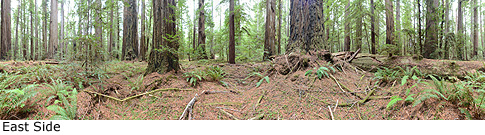
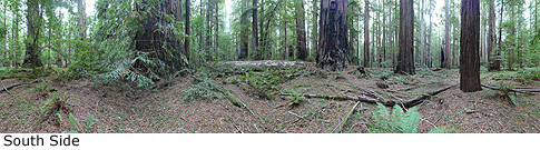
Photos: Pictures of Bull Creek Giant Tree taken from different sides