| Height: | 353.40+ ft | (107.72+ m) | Elevation: | 159 ft (48 m) | GPS Latitude: | 40.37895 |
| Volume: | 317 m3 | (11,212 ft3) | Creek: | Eel River | GPS Longitude: | -123.92403 |
| Width: | 11.00 ft | (3.35 m) | Grove: | Starr Grove | Discovery Date: | December 21, 2017 |
| Age: | Park: | Humboldt Redwoods SP | Discovered By: | LiDAR |
Notes: Solstice is the tallest tree in Walter A. and Carmen Starr Grove. Naturalist Michael W. Taylor named the tree Solstice because he first measured the tree on the winter solstice (December 21, 2017).
In spring 2007, the National Park Service, the Bureau of Land Management, the California State Parks Foundation, the Nature Conservancy, and Save the Redwoods League paid Sanborn Mapping Services $183,000 to conduct an aerial LiDAR survey of Redwood National and State Parks, the Headwaters Forest Reserve, and Humboldt Redwoods State Park. Over a period of three months, Sanborn's 1968 Aero Commander 500S aircraft, carrying Leica Geosystems topographic LiDAR sensors, flew back and forth above the parks, at an altitude of 2,625 ft (800 m), while a laser, firing through a hole in the bottom of the fuselage, scanned the terrain below. The aircraft traveled more than 13,500 mi (21,726 km) during the survey while LiDAR sensors recorded the precise location, between the ground and the treetops, of 85,000 points every second to generate a three-dimensional map of the forest. After researchers processed the LiDAR data to create a list of trees taller than 348 ft (106 m) in each park, they hiked to each tree to verify its height. Although many tall redwoods detected by LiDAR, including Hyperion and Helios, were already known from earlier ground surveys, some trees, including Gulch Tower, Orion, Outlier, and Solstice, were previously undiscovered.
Drive: Solstice is 197 mi (317 km) north of San Francisco near the community of Redcrest.
Northbound: From U.S. Highway 101 just north of Weott, take exit 663 South Fork Honeydew and turn left onto California State Route 254 (Avenue of the Giants). Drive north 2.0 mi (3.2 km) on California State Route 254 (Avenue of the Giants) to the parking spot, near 40.37811 -123.92518, on the right/east side of the road.
Southbound: From U.S. Highway 101 just south of Redcrest, take exit 667A Avenue of the Giants Scenic Alternate and turn right onto California State Route 254 (Avenue of the Giants). Drive south 1.6 mi (2.6 km) on California State Route 254 (Avenue of the Giants) to the parking spot, near 40.37811 -123.92518, on the left/east side of the road.
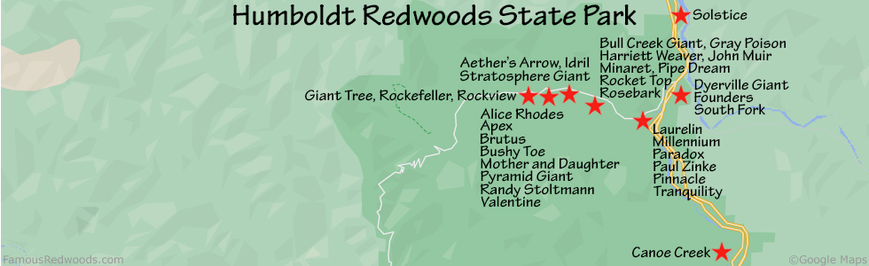
Hike: From the parking spot, walk southeast to the trailhead and hike east/downhill 250 ft (76 m) to the junction with High Rock River Trail. Turn left at the trail junction, near a small bridge, and hike north 500 ft (152 m) on High Rock River Trail, past the Starr Grove sign, to the trail exit point, near 40.37869 -123.92462, just past a large snag. Turn right here and hike northeast 200 ft (61 m) off-trail to Solstice.
| Rating: | Easy | One-Way Distance: | 0.2 mi | (0.3 km) | Ascent: | 0 ft | (0 m) |
| Time: | 5 min | Off-Trail: | 200 ft | (61 m) | Descent: | 40 ft | (12 m) |

View Solstice Tree location in Google Maps
Panorama: Click panorama to take a virtual tour of Solstice Tree

Photos: Pictures of Solstice Tree taken from different sides


