| Height: | 378.80+ ft | (115.46+ m) | Elevation: | 332 ft (101 m) | GPS Latitude: | 41.25990 |
| Volume: | 20,500 ft3 | (581 m3) | Creek: | Elam Creek | GPS Longitude: | -124.03302 |
| Width: | 16.00 ft | (4.88 m) | Grove: | Helios Grove | Discovery Date: | July 1, 2006 |
| Age: | 2,053 y | Park: | Redwood NP | Discovered By: | Chris K. Atkins | |
| Michael W. Taylor |
Notes: Helios is the world's 2nd tallest tree, the 2nd tallest and 6th largest tree in Redwood National Park, and the tallest and largest tree in Helios Grove. Naturalists Chris K. Atkins and Michael W. Taylor named the tree after the Greek Titan Helios, god of the sun and son of Hyperion, because its treetop remained sunlit when first spotted near sunset on July 1, 2006. Helios held the title of world's tallest tree from July 1, 2006 until August 25, 2006 when Atkins and Taylor discovered Hyperion in Redwood National Park. Elam Creek is also known as Dry Heaves Creek.
Helios has the largest measured crown, 696,050 ft3 (19,710 m3), in Redwood National Park [3rd largest in Redwood National and State Parks behind Iluvatar, 915,500 ft3 (25,924 m3), and Atlas, 912,740 ft3 (25,846 m3)] and contains over 560 million leaves. The main trunk tapers sharply, just above a large burl, about 59 ft (18 m) above average ground level. The tallest leader is a reiterated trunk.
Author Richard M. Preston photographed Save the Redwoods League naturalists Ruskin K. Hartley and Kenya Lewis and biologists Marie E. Antoine and James C. Spickler approaching Helios before the September 17, 2006 first climb. The film In Search of the Tallest: A Redwoods Adventure includes a segment about Helios. Videographer Steven D. Smith visited Helios.
Contrary to what many researchers have claimed, the 1978 expansion of Redwood National Park did not save the world's tallest trees; Helios and Hyperion grow within the original 1968 park boundary.
Drive: Helios is 255 mi (410 km) north of San Francisco near the community of Orick.
From U.S. Highway 101 just north of Orick, turn onto Bald Hills Road and drive 0.3 mi (0.5 km) to the Redwood Creek Trail sign. Turn right at the sign and drive 0.5 mi (0.8 km) to the Redwood Creek trailhead parking lot.
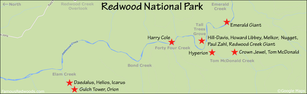
Hike: GPS-assisted navigation is recommended for this hike. At the southern end of the parking lot, cross the bridge at the trailhead and hike south 1.7 mi (2.7 km) on Redwood Creek Trail to the creek crossing. Cross the seasonal footbridge, if available, return to the trail on the western creek bank, and hike south another 1.0 mi (1.6 km) on Redwood Creek Trail, past McArthur Creek, to the junction with Elam Camp Trail, near 41.26398 -124.02606, just before the lower Elam Creek bridge (turn around if you reach this bridge). Turn right/west at the trail junction and hike west 0.1 mi (0.2 km) on Elam Camp Trail, past Elam Camp and stable, to the junction with Elam Creek Loop Trail (also known as Overnight Loop Trail). Veer left at the trail junction and hike west 0.2 mi (0.3 km) on Elam Creek Loop Trail to the upper Elam Creek bridge and your first view of Daedalus and Icarus. Hike east 150 ft (46 m) past the bridge to the trail exit point, near 41.26170 -124.03076, just before a small gully (turn around if you reach this gully). Exit the trail here and hike west/uphill on an old logging road to the road exit point, near 41.26114 -124.03161, where the road veers left/south away from Elam Creek. Leave the road here and, using a GPS device, hike southwest 0.1 mi (0.2 km) off-trail, past Daedalus and Icarus, to Helios. After visiting Helios, hike northeast 0.1 mi (0.2 km) off-trail to Daedalus and Icarus, hike west 0.2 mi (0.3 km) off-trail to Gulch Tower, or hike southwest 0.3 mi (0.5 km) off-trail to Orion.
Creek Warning: Helios is not accessible via Redwood Creek Trail when Redwood Creek has high water levels and the seasonal footbridge is not installed. It is best to visit Orion from July through October when Redwood Creek is low enough to wade across. To visit Orion whenever Redwood Creek is impassable, use the 3.1 mi (5.0 km) longer alternate route via Orick Horse Trail.
| Rating: | Moderate | One-Way Distance: | 3.2 mi | (5.1 km) | Ascent: | 741 ft | (226 m) |
| Time: | 2 hr | Off-Trail: | 0.2 mi | (0.3 km) | Descent: | 494 ft | (151 m) |

View Helios Tree location in Google Maps
Panoramas: Click panoramas to take a virtual tour of Helios Tree


Photos: Pictures of Helios Tree taken from different sides


