| Height: | 277.90+ ft | (84.70+ m) | Elevation: | 6,160 ft (1,878 m) | GPS Latitude: | 36.69596 |
| Volume: | 34,407 ft3 | (974 m3) | Creek: | East Fork Redwood Creek | GPS Longitude: | -118.89171 |
| Width: | 21.29 ft | (6.49 m) | Grove: | Redwood Mountain Grove | Discovery Date: | 1880 |
| Age: | Park: | Kings Canyon NP | Discovered By: | Michael Hart | ||
| William H. Hart |
Notes: Before the 2021 KNP Complex Fire, Hart was the world's 30th largest tree, the 27th largest giant redwood, the 6th largest tree in Kings Canyon National Park, and the 2nd largest tree in Redwood Mountain Grove. Once considered a contender for world's largest tree, Hart was identified as 4th largest in 1931 when a team of engineers, led by J. W. Jourdan of the San Joaquin Light and Power Corporation, measured the four then-largest-known redwoods (Boole, Hart, General Grant, and General Sherman) and determined that General Sherman was the true size champion. Other giant redwoods have since surpassed Hart in volume. The trunk lost significant height and volume after it burned, and, pending updated volume estimates, Hart likely no longer ranks among the 30 largest giant redwoods.
Hart should not be confused with Roosevelt (also known as False Hart) which stands 120 ft (37 m) uphill. Although a sign near Roosevelt suggests that tree is Hart, the real Hart tree stands downhill from and closer to Hart Tree Trail than Roosevelt. Both N. E. Beckwith, a member of the Jourdan Team who measured Hart in 1931, and L. N. (Pat) Hart, a descendant of Hart tree discoverers Michael and William H. Hart, confirmed that the lower tree is indeed the real Hart. Moreover, the lower tree appears in a 1928 photograph of Hart.
Drive: Hart is 208 km (335 km) southeast of San Francisco near Fresno.
Northbound: From U.S. Interstate 5 North, transfer to California State Route 99 North toward Bakersfield. Drive north 97 mi (156 km) on California State Route 99 and transfer to California State Route 198 East toward Visalia. Drive east 82 mi (132 km) on California State Route 198 (Generals Highway), past the Sequoia National Park entrance station (entrance fee required) and Four Guardsmen, and turn left onto Forest Service Road 14S75 (Redwood Mountain Road) toward Redwood Canyon.
Southbound: From U.S. Interstate 5 South in Sacramento, transfer to U.S. Highway 50 East toward South Lake Tahoe. Drive east 1.7 mi (2.7 km) on U.S. Highway 50 and transfer to California State Highway 99 South. Near Fresno, transfer to California State Route 180 East. Drive east 56 mi (90 km) on California State Route 180, past the Kings Canyon National Park entrance station (entrance fee required), and turn right onto California State Route 198 West. Drive south 4 mi (6 km) on California State Route 198 (Generals Highway) and turn right onto Forest Service Road 14S75 (Redwood Mountain Road) toward Redwood Canyon.
Drive southwest 1.8 mi (2.9 km) on Forest Service Road 14S75 (Redwood Mountain Road) and turn left into the Redwood Canyon Trailhead parking lot.
Road Warning: Forest Service Road 14S75 (Redwood Mountain Road) is closed during winter. This unpaved road usually opens on the Wednesday before Memorial Day and closes when it becomes impassible due to snow.
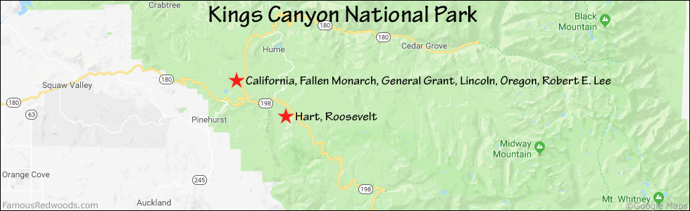
Hike: From the trailhead, hike east 3.3 mi (5.3 km) on Hart Tree Trail, past the junction with Redwood Creek Trail, to Hart and Roosevelt which stand just above the trail on your left. After visiting Hart, hike south/uphill 120 ft (37 m) to Roosevelt. Although a sign near Roosevelt suggests that tree is Hart, the real Hart tree stands downhill from and closer to Hart Tree Trail than Roosevelt.
| Rating: | Easy | One-Way Distance: | 3.3 mi | (5.3 km) | Ascent: | 726 ft | (221 m) |
| Time: | 1 hr 15 min | Off-Trail: | 0 ft | (0 m) | Descent: | 808 ft | (246 m) |

View Hart Tree location in Google Maps
Panoramas: Click panoramas to take a virtual tour of Hart Tree


Photos: Pictures of Hart Tree taken from different sides


