
| Height: | 262.00+ ft | (79.86+ m) | Elevation: | 4,906 ft (1,495 m) | GPS Latitude: | 38.24838 |
| Volume: | 30,580 ft3 | (866 m3) | Creek: | Big Trees Creek | GPS Longitude: | -120.24172 |
| Width: | 22.28 ft | (6.79 m) | Grove: | South Grove | Discovery Date: | |
| Age: | Park: | Calaveras Big Trees SP | Discovered By: |
Notes: Louis Agassiz, named to honor Swiss-American biologist and geologist Jean Louis Rodolphe Agassiz, is the world's 29th largest tree, the 26th largest giant redwood, and the largest tree in Calaveras Big Trees State Park.
Nearby famous redwoods include Palace HotelSmith Cabin
Drive: Louis Agassiz is 123 mi (198 km) east of San Francisco near the community of Arnold.
From U.S. Interstate 5 in Stockton, transfer to California State Route 4 East. Drive east 74 mi (119 km) on California State Route 4 East to the entrance to Calaveras Big Trees State Park. Turn right onto Big Trees Parkway (also known as Walter W. Smith Memorial Parkway), pass the park entrance station (entrance fee required), and drive southeast 8.4 mi (13.5 km) on Big Trees Parkway to the South Grove Trailhead parking lot.


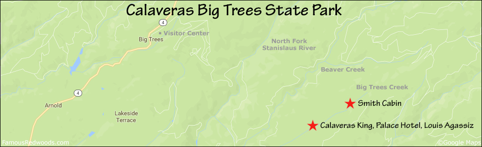
Hike: From the trailhead at the southern edge of the parking lot, hike south 0.2 mi (0.3 km) on Beaver Creek Trail, past the junction with the northern half of the Beaver Creek Trail loop (which leads to the Beaver Creek Picnic Area), to the junction with South Grove Trail. Turn right at the trail junction and hike south then northeast 2.2 mi (3.5 km) on South Grove Trail, across the bridge over Beaver Creek, past the junction with Bradley Grove Trail, across Beaver Creek Road, past the (western and eastern) junctions with South Grove Loop Trail, and past Calaveras King and Palace Hotel, to Louis Agassiz. After visiting Louis Agassiz, hike southwest 0.1 mi (0.2 km) on South Grove Trail to Palace Hotel then hike southwest another 0.1 mi (0.2 km) on South Grove Trail to Calaveras King.


| Rating: | Easy | One-Way Distance: | 2.4 mi | (3.9 km) | Ascent: | 1,209 ft | (369 m) |
| Time: | 1 hour | Off-Trail: | 0 ft | (0 m) | Descent: | 727 ft | (222 m) |

View Louis Agassiz Tree location in Google Maps
Panoramas: Click panoramas to take a virtual tour of Louis Agassiz Tree


Photos: Pictures of Louis Agassiz Tree taken from different sides


