| Height: | 215.00+ ft | (65.53+ m) | Elevation: | 287 ft (87 m) | GPS Latitude: | 41.81369 |
| Volume: | 21,470 ft3 | (608 m3) | Creek: | Clarks Creek | GPS Longitude: | -124.10750 |
| Width: | 19.00 ft | (5.79 m) | Grove: | Skinner and Stelter Grove | Discovery Date: | |
| Age: | Park: | Jedediah Smith Redwoods SP | Discovered By: | |||
Notes: Fesler, also known as Fessler and Simpson-Reed Giant, is the 11th largest tree in Jedediah Smith Redwoods State Park and the largest tree in Ruth Adams Skinner and Leona Ann Stelter Redwood Grove. Athough the tree was named for nearby David R. and Sherrill E. Fesler Grove and Simpson-Reed Grove, it actually stands within Ruth Adams Skinner and Leona Ann Stelter Redwood Grove.
Drive: Fesler is 293 mi (472 km) north of San Francisco near Crescent City.
Northbound: From U.S. Highway 101, 5 mi (8 km) north of Crescent City, take exit 794 to merge onto U.S. Highway 199. Drive east 2.8 mi (4.5 km) on U.S. Highway 199 and turn left onto Walker Road.
Southbound: From U.S. Highway 101, 5 mi (8 km) north of Crescent City, turn left onto Elk Valley Cross Road. Drive southeast 0.3 mi (0.5 km) on Elk Valley Cross Road and turn left onto U.S. Highway 199. Drive east 2.3 mi (3.7 km) on U.S. Highway 199 and turn left onto Walker Road.
Drive north 140 ft (43 m) on Walker Road and park at one of the turnouts near signs for Walker Road Day Use Area or David R. and Sherrill Fesler Grove.
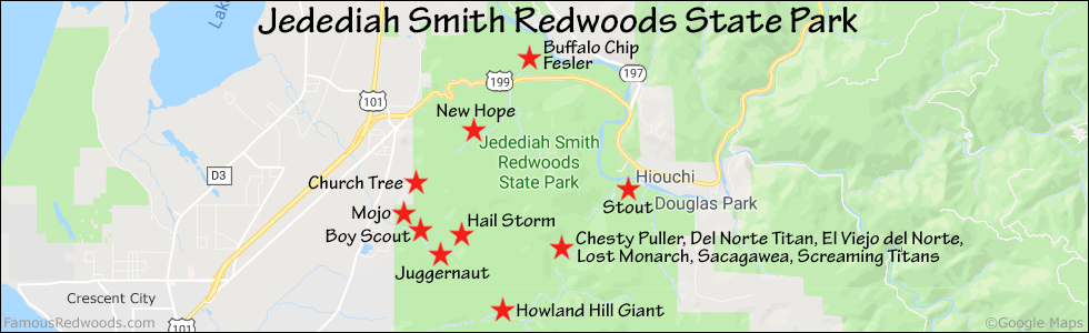
Hike: From the turnout, walk north 230 ft (70 m) on Walker Road to the trailhead just south of the bridge over Clarks Creek. Walk past the trailhead sign, turn right, and hike east 430 ft (131 m) on Simpson-Reed Trail. Turn left/north at the fork in the trail and hike 400 ft (122 m) to Fesler which stands beside the trail on your left.
| Rating: | Easy | One-Way Distance: | 0.2 mi | 0.3 km | Ascent: | 28 ft | 9 m |
| Time: | 5 min | Off-Trail: | 0 ft | 0 m | Descent: | 23 ft | 7 m |

View Fesler Tree location in Google Maps
Panorama: Click panorama to take a virtual tour of Fesler Tree

Photos: Pictures of Fesler Tree taken from different sides


