
| Height: | 321.19+ ft | (97.90+ m) | Elevation: | 377 ft (115 m) | GPS Latitude: | 41.77664 |
| Volume: | 23,876 ft3 | (676 m3) | Creek: | Mill Creek | GPS Longitude: | -124.10123 |
| Width: | 21.75 ft | (6.63 m) | Grove: | Grove of Titans | Discovery Date: | May 11, 1998 |
| Age: | 1,523 y | Park: | Jedediah Smith Redwoods SP | Discovered By: | Stephen C. Sillett | |
| Michael W. Taylor |
Notes: is the 28th largest coast redwood, the 8th largest tree in Jedediah Smith Redwoods State Park, the 6th largest tree in National Tribute Grove, and the 4th largest tree in the Grove of Titans. Cal Poly Humboldt forestry professor Stephen C. Sillett and naturalist Michael W. Taylor named the tree to honor Lemhi Shoshone Native American Sacagawea who served as both guide and interpreter for the Lewis and Clark Expedition from 1805 to 1806.
Nearby famous redwoods include Boy ScoutBuffalo ChipChesty PullerChurch TreeDel Norte TitanElk HerdEl Viejo del NorteFeslerHail StormHowland Hill GiantJuggernautJupiterLost MonarchMojoNew HopeScreaming TitansStout
Drive: Sacagawea is 290 mi (467 km) north of San Francisco near Crescent City.
Northbound: From U.S. Highway 101, just south of Crescent City, turn right onto Humboldt Road. Drive north 1.5 mi (2.4 km) on Humboldt Road and turn right onto Howland Hill Road. Drive east 3.8 mi (6.1 km) on Howland Hill Road, past Howland Hill Giant and a restroom, to the Grove of Titans Trailhead parking area located near 41.77243 -124.09940.


Southbound: From U.S. Highway 101, just north of Crescent City, turn left onto California State Route 197 (North Bank Road). Drive south 6.7 mi (10.8 km) on California State Route 197 (North Bank Road) and turn left onto U.S. Highway 199. Drive east 2.8 mi (4.5 km) on U.S. Highway 199 and turn right onto County Road 427 (South Fork Road). Drive south 0.5 mi (0.8 km) on County Road 427 (South Fork Road) and turn right onto Douglas Park Drive. Drive West 1.3 mi (2.1 km) on Douglas Park Drive to the intersection with Pacomo Camp Drive. Continue straight onto Howland Hill Road and drive west 2.5 mi (4.0 km) to the Grove of Titans Trailhead parking area located near 41.77243 -124.09940.


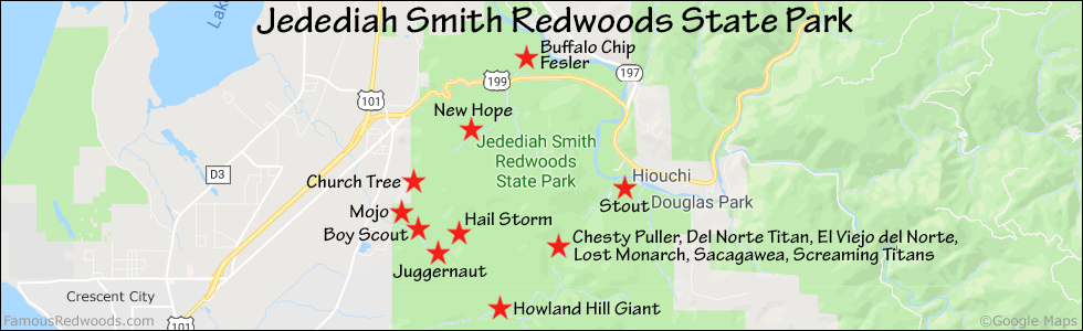
Hike: From the trailhead, hike north 0.5 mi (0.8 km) on Mill Creek Trail to the point where the trail turns right/south beside a large, fallen log on your left. Sacagawea stands to your right/west just across the trail from the fallen log.


| Rating: | Easy | One-Way Distance: | 0.5 mi | (0.8 km) | Ascent: | 108 ft | (33 m) |
| Time: | 30 min | Off-Trail: | 0 ft | (0 m) | Descent: | 79 ft | (24 m) |

View Sacagawea Tree location in Google Maps
Panorama: Click panorama to take a virtual tour of Sacagawea Tree

Photos: Pictures of Sacagawea Tree taken from different sides


