| Height: | 366.50+ ft | (111.71+ m) | Elevation: | 250 ft (76 m) | GPS Latitude: | 40.35135 |
| Volume: | 20,000 ft3 | (566 m3) | Creek: | Bull Creek | GPS Longitude: | -123.99229 |
| Width: | 15.20 ft | (4.63 m) | Grove: | Upper Bull Creek Flat | Discovery Date: | 1957 |
| Age: | Park: | Humboldt Redwoods SP | Discovered By: | Gerald L. Partain |
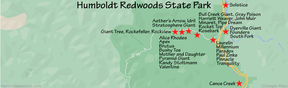
Notes: Rockefeller, also known as Tall Tree, Tallest Tree, Fourth Tallest Tree (1963), and Jerry Partain Tree, is the world's 16th tallest tree, the 10th tallest and 8th largest tree in Humboldt Redwoods State Park, and the tallest and 2nd largest tree on Upper Bull Creek Flat. Rockefeller was named to honor John D. Rockefeller Jr. who, between 1926 and 1929, donated $2,000,000 to Save the Redwoods League to purchase Dyerville Flat from the Pacific Lumber Company. In 1931, this 14.6 mi2 (37.8 km2) tract of old-growth redwood forest, since renamed Rockefeller Forest, became the core of Humboldt Redwoods State Park.
Rockefeller held the title of world's tallest tree from 1957 until 1963 when National Geographic Society senior scientist Paul A. Zahl discovered Howard Libbey in Redwood National Park. Rockefeller is now 7.2 ft (2.2 m) taller than a nearby sign indicates: 359.3 ft (109.5 m) in 1957.
Drive: Rockefeller is 197 mi (317 km) north of San Francisco near the community of Weott.
Northbound: From U.S. Highway 101 just north of Weott, take exit 663 South Fork Honeydew and turn left onto California State Route 254 (Avenue of the Giants). Drive north 0.2 mi (0.3 km) on California State Route 254 (Avenue of the Giants) and turn left, under the bridge, onto Mattole Road.
Southbound: From U.S. Highway 101 just north of Weott, take exit 663 South Fork Honeydew and turn right onto Mattole Road.
Drive west 4.4 miles (7.1 km) on Mattole Road to the entrance for the Big Trees Area. Turn left here and continue to the Big Trees Area parking lot.
Hike: From the parking lot, hike northwest 90 ft (27 m) on Big Trees Trail, past the trailhead marker, to the
Tall Tree sign. Turn right and hike north 250 ft (76 m) to Rockefeller. Another sign, beside the tree, identifies Rockefeller
as Tall Tree.
| Rating: | Easy | One-Way Distance: | 280 ft | (85 m) | Ascent: | 0 ft | (0 m) |
| Time: | 3 min | Off-Trail: | 0 ft | (0 m) | Descent: | 0 ft | (0 m) |

View Rockefeller Tree location in Google Maps
Panoramas: Click panoramas to take a virtual tour of Rockefeller Tree


Photos: Pictures of Rockefeller Tree taken from different sides


