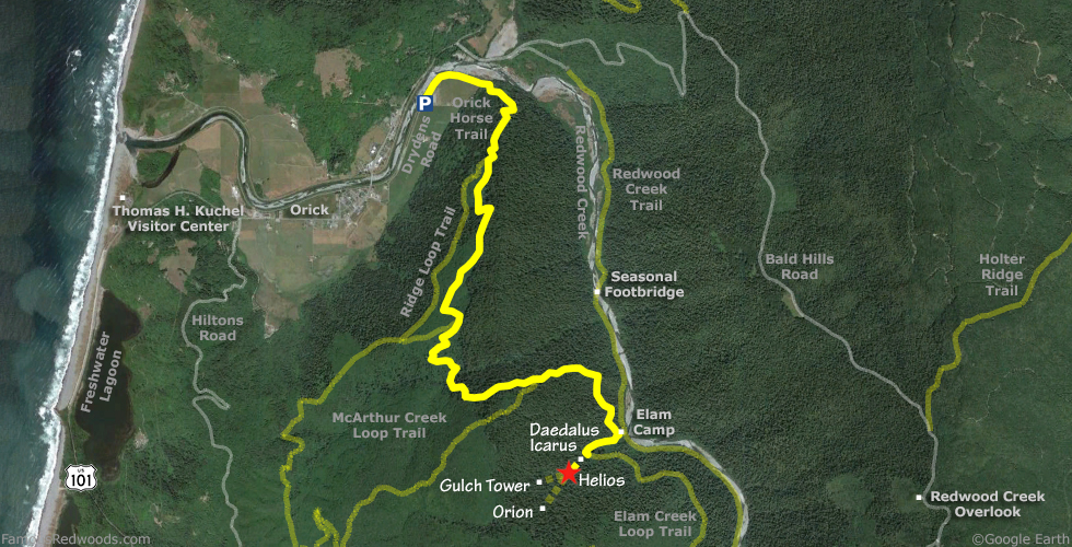
Notes: Use this alternate route to visit Helios whenever Redwood Creek is impassable. If the seasonal footbridge over Redwood Creek is installed or Redwood Creek is low enough to wade across, use the 3.1 mi (5.0 km) shorter normal route to Helios via Redwood Creek Trail instead.
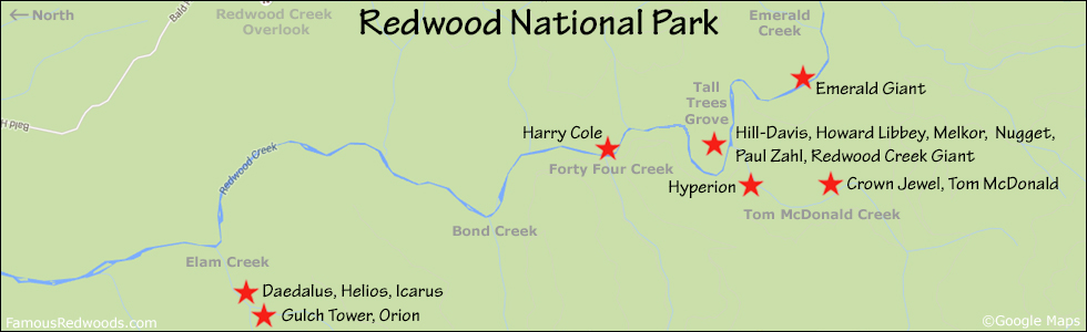
Drive: Helios is 255 mi (410 km) north of San Francisco near the community of Orick.
From Highway 101 near Orick School, turn onto Drydens Road, drive north 0.9 mi (1.4 km) to Orick Rodeo Grounds, and park at the unpaved parking lot.
Hike: GPS-assisted navigation is recommended for this hike. From the parking lot, follow a short trail northwest to the levee. Hike northeast 0.5 mi (0.8 km) along the levee to Orick Horse Trail. From the trailhead, hike south 1.1 mi (1.8 km) on Orick Horse Trail to Ridge Loop Trail (also known as Three Hour Loop Trail). Turn left onto Ridge Loop Trail and hike south 1.5 mi (2.4 km) to McArthur Creek Loop Trail (also known as Six Hour Loop Trail). Turn left again and hike south 1.7 mi (2.7 km) on McArthur Creek Loop Trail to Elam Creek Loop Trail (also known as Overnight Loop Trail). Turn left on Elam Creek Loop Trail and hike 1.1 mi (1.8 km) southeast to the junction with Elam Camp Trail. Turn right at the trail junction and continue hiking west on Elam Creek Loop Trail, following the normal route, from Elam Camp to Helios.
| Rating: | Moderate | One-Way Distance: | 6.3 mi | (10.1 km) | Ascent: | 2,401 ft | (732 m) |
| Time: | 3 hr 30 min | Off-Trail: | 0.2 mi | (0.3 km) | Descent: | 2,104 ft | (641 m) |
View Helios Tree location in Google Maps