| Height: | 48.39+ ft | (14.75+ m) | Elevation: | 10,750 ft (3,277 m) | GPS Latitude: | 36.28690 |
| Volume: | Creek: | Kyle Canyon Creek | GPS Longitude: | -115.67427 | ||
| Width: | 12.23 ft | (3.73 m) | Grove: | Discovery Date: | 2003 | |
| Age: | Park: | Spring Mountains NRA | Discovered By: | Bruce A. Van Pelt | ||
| Robert S. Van Pelt |
Notes: Bob's Big Boy, named to honor University of Washington forestry affiliate assistant professor Robert S. Van Pelt (also known as Big Tree Bob), who discovered the tree with his brother Bruce A. Van Pelt in 2003, is the largest-known and current national champion Great Basin bristlecone pine (523 points).
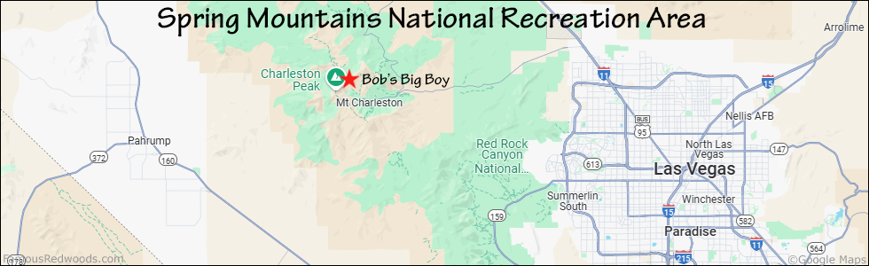
Drive: Bob's Big Boy is 30 mi (48 km) northwest of Las Vegas near the community of Mount Charleston.
From US Interstate 11 just northwest of Las Vegas, take exit 96 Kyle Canyon/Sunstone Pkwy. Drive west 20 mi (32 km) on Nevada State Route 157 (Kyle Canyon Road) to the intersection with Echo Road. Continue straight at the intersection and drive northwest 0.5 mi (0.8 km) on Echo Road to the Trail Canyon Trailhead parking lot on the left/west side of the road.
Hike: GPS-assisted navigation is recommended for this hike. From the trailhead at the northern end of the parking lot, hike north 2.0 mi (3.2 km) on Trail Canyon Trail to the junction with North Loop Trail. Turn left at the trail junction and hike west 2.8 mi (4.5 km) on North Loop Trail to the trail exit point near 36.28755 -115.67377. Leave the trail here and, using a GPS device, hike southwest/downhill 300 ft (91 m) to Bob's Big Boy.
| Rating: | Difficult | One-Way Distance: | 4.8 mi | (7.7 km) | Ascent: | 3,412 ft | (1,040 m) |
| Time: | 4 hr 30 min | Off-Trail: | 300 ft | (91 m) | Descent: | 440 ft | (134 m) |

View Bob's Big Boy Tree location in Google Maps
Panoramas: Click panoramas to take a virtual tour of Bob's Big Boy Tree


Photos: Pictures of Bob's Big Boy Tree taken from different sides


