
| Height: | 268.50+ ft | (81.84+ m) | Elevation: | 5,237 ft (1,596 m) | GPS Latitude: | 38.25582 |
| Volume: | 31,225 ft3 | (884 m3) | Creek: | Big Trees Creek | GPS Longitude: | -120.22517 |
| Width: | 19.80 ft | (6.04 m) | Grove: | South Grove | Discovery Date: | |
| Age: | Park: | Calaveras Big Trees SP | Discovered By: |
Notes: Smith Cabin, named to honor Alexander Jackson "Trapper" Smith, is the 2nd largest tree in Calaveras Big Trees State Park and the 2nd largest tree in South Grove. Smith used the 21 ft (6.4 m) x 16 ft (4.9 m) hollow within the trunk as a makeshift cabin from 1859 until December 1861 while working as a fisherman, guide, and handyman for the Mammoth Grove/Calaveras Big Trees Hotel in North Grove. Dan Phillips, a United States Forest Service fireguard, lived inside Smith Cabin during the 1930s while constructing a traditional cabin nearby.
A prescribed burn to reduce excess forest fuels and to promote giant redwood regeneration, performed by California State Parks, California Department of Forestry and Fire Protection (CAL FIRE), and the United States Forest Service from October 29 to November 1, 2024, enlarged the opening on the southeast side of Smith Cabin's trunk. No wildfires have burned in South Grove in modern recorded history.
Nearby famous redwoods include Louis AgassizPalace Hotel
Drive: Smith Cabin is 124 mi (200 km) east of San Francisco near the community of Arnold.
From U.S. Interstate 5 in Stockton, transfer to California State Route 4 East. Drive east 74 mi (119 km) on California State Route 4 East to the entrance to Calaveras Big Trees State Park. Turn right onto Big Trees Parkway (also known as Walter W. Smith Memorial Parkway), pass the park entrance station (entrance fee required), and drive southeast 8.4 mi (13.5 km) on Big Trees Parkway to the South Grove Trailhead parking lot.


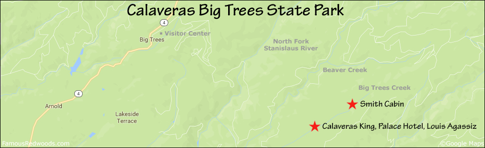
Hike: GPS-assisted navigation is recommended for this hike. From the trailhead at the southern edge of the parking lot, hike south 0.2 mi (0.3 km) on Beaver Creek Trail, past the junction with the northern half of the Beaver Creek Trail loop (which leads to the Beaver Creek Picnic Area), to the junction with South Grove Trail. Turn right at the trail junction and hike south then northeast 2.2 mi (3.5 km) on South Grove Trail, across the bridge over Beaver Creek, and past the junction with Bradley Grove Trail, to the intersection with Beaver Creek Road. Turn left at the intersection, and hike northeast 0.7 mi (1.1 km) on Beaver Creek Road to the intersection with North Side Rim Road. Turn right at the intersection and hike northeast 2.3 mi (3.7 km) on North Side Rim Road to the road exit point near near 38.25945 -120.22624. Exit the road here, near a distinctive, slingshot-shaped tree on your right, and, using a GPS device, hike south/downhill 0.3 mi (0.5 km) off-trail to Smith Cabin.


| Rating: | Moderate | One-Way Distance: | 4.3 mi | (6.9 km) | Ascent: | 1,665 ft | (507 m) |
| Time: | 2 hr 30 min | Off-Trail: | 0.3 mi | (0.5 km) | Descent: | 860 ft | (262 m) |

View Smith Cabin Tree location in Google Maps
Panoramas: Click panoramas to take a virtual tour of Smith Cabin Tree


Photos: Pictures of Smith Cabin Tree taken from different sides


